
Sunrise out here is about 7:40, so it was dark when I hit the road a little after 7. When the sun came up, I was heading west on US-90:

(they didn't have any mid-size cars at Thrifty, so they upgraded me to a "Luxury Car" - a black Chevy Impala. It drives pretty well on the highway, but I'm a little concerned about its dirt-road-capability.)
There sure is a lot of open space out here in southwest Texas. Looking west (ahead of me):

looking north:

looking east (behind me):

looking south:

I reached Big Bend National Park at noon:

Once I got to the Park, I still had a pretty aggressive day planned:

Its nice and warm out here in the Park:

We'll see how it goes the rest of the week!
At the center of Big Bend is the Chisos Mountain Range (yes, it has ITS OWN MOUNTAIN RANGE):

and they make a wonderful, reassuring landmark as you drive around the Park.
At the Panther Junction Visitor Center I got my backcountry permit for the next 3-days/2-nights (just walk up to the desk - no online service - not enough demand). Senior Rate = $5/day. Was asked if I knew about the weather coming in. This is what I had seen Sunday back in Massachusetts:

Well, I've skied in snow ... and when you hike, you're all warmed up ... and I'm in really/pretty good shape ... and I've got my down parka & winter hat & neckwarmer & gloves ...
So we'll see.
Mailed postcards at their Post Office:

And then headed over to Grapevine Spring Road - 6 miles of dirt road, ending at Grapevine Hills Trail:


What a LOVELY desert trail:


(can you see the people hiking?)
The trail goes up to ICONIC Balanced Rock:

which has been on the cover of Frommer's Texas guidebook:

and the Big Bend chapter in a National Parks book:

Google Earth does a nice job showing the hike:

Pretty cool view on the way back down:

Can you see the hiker?

There is a lot of ground to cover out here. I went south down into the Chisos Basin to see what it was like:

and then back out and southwest to do the Ross Maxwell Scenic Drive:

Great views of the mountains:

and the valleys:


I made it down to the southwest corner of the Park - Santa Elena Canyon - by 5:50 (sunrise is 7:40 AM, sunset is 6:30 PM):


To get up into the canyon, you have to cross a little mud flat. It had rained here earlier today, so the mud was deep (both my boots went in all-the-way) and very clay-like. Also, I don't know what MapMyWalk was thinking, but I DID NOT GO UP AND DOWN THE CANYON WALLS. I also DID NOT JUMP ACROSS THE RIO GRANDE:
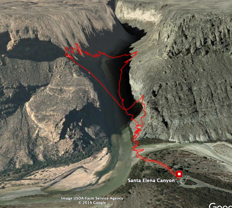
I did get some pretty cool views looking up into the Canyon:

as well as looking back out:

I got out of there just as the sun was setting. The road I wanted to take up to Terlingua is "Old Maverick Road", which is 12 1/2 miles of "improved dirt road". I really don't care how "improved" it is - I'm too old to be driving a RENTAL CAR down an UNKNOWN DIRT ROAD in the DARK!!!
Well, I made it ok, and checked in to the Big Bend Motor Inn at 7:30. Went down the road and had a GREAT steak at la Kiva Restaurant & Bar - good enough to bring me back for dinner for the next 2 nights.
Yes, that means that I got scared and bailed on the whole "camping out in the snow" thing, and was able to book my room (and hot shower and big cozy bed) for the next 2 nights! I'm sure I can figure out some cool hiking out here in Southwest Texas.
Thank You God for these WONDERFUL Adventures, and for getting me here safe and sound!
Driving Music:
Started out listening to KONO 101.1 San Antonio's Greatest Hits:

and then a few miles down the road changed to 104.9 KVOU-FM "Coyote Country":
a surprisingly good country station!
This car did not have any AUX input, but I figured I could listen to my Boom Cube and my green nano:

the Rolling Stones - More Hot Rocks (Big Hits & Fazed Cookies), 1972 double album:

Steve Miller Band - Number 5, 1970

With songs like "Hot Chili" and "Going to Mexico", it is a perfect album for this part of the country.
Paul Simon - Paul Simon, 1972 first solo album

Rickie Lee Jones - Pirates, 1982 second album

Jamie Cullum - The Pursuit, 2009

No comments:
Post a Comment