So now I'm out in Zion again, to hike some Really Cool Trails that I couldn't get to before:
East Rim Trail
Canyon Overlook Trail
West Rim Trail/Telephone Canyon Trail
back in Kolob Canyons: Timber Creek Overlook Trail/South Fork Taylor Creek Trail/Middle Fork Taylor Creek Trail/North Fork Taylor Creek Trail
Today I'll be up in Kolob Canyons, doing Timber Creek Overlook Trail/South Fork Taylor Creek Trail/Middle Fork Taylor Creek Trail/North Fork Taylor Creek Trail. Similar to yesterday's "visual problem", this is from the "main hiking map for Zion National Park" [Trails Illustrated Topographic Map by National Geographic]:

It all looks kind-of washed out, and you certainly cannot tell that there are AWESOME buttes and canyons off to the east (the right)
So let's look at today's hikes in Google Earth - first from the south:

Well, doesn't that look cool!
And then viewed from the east:
 and then from the west:
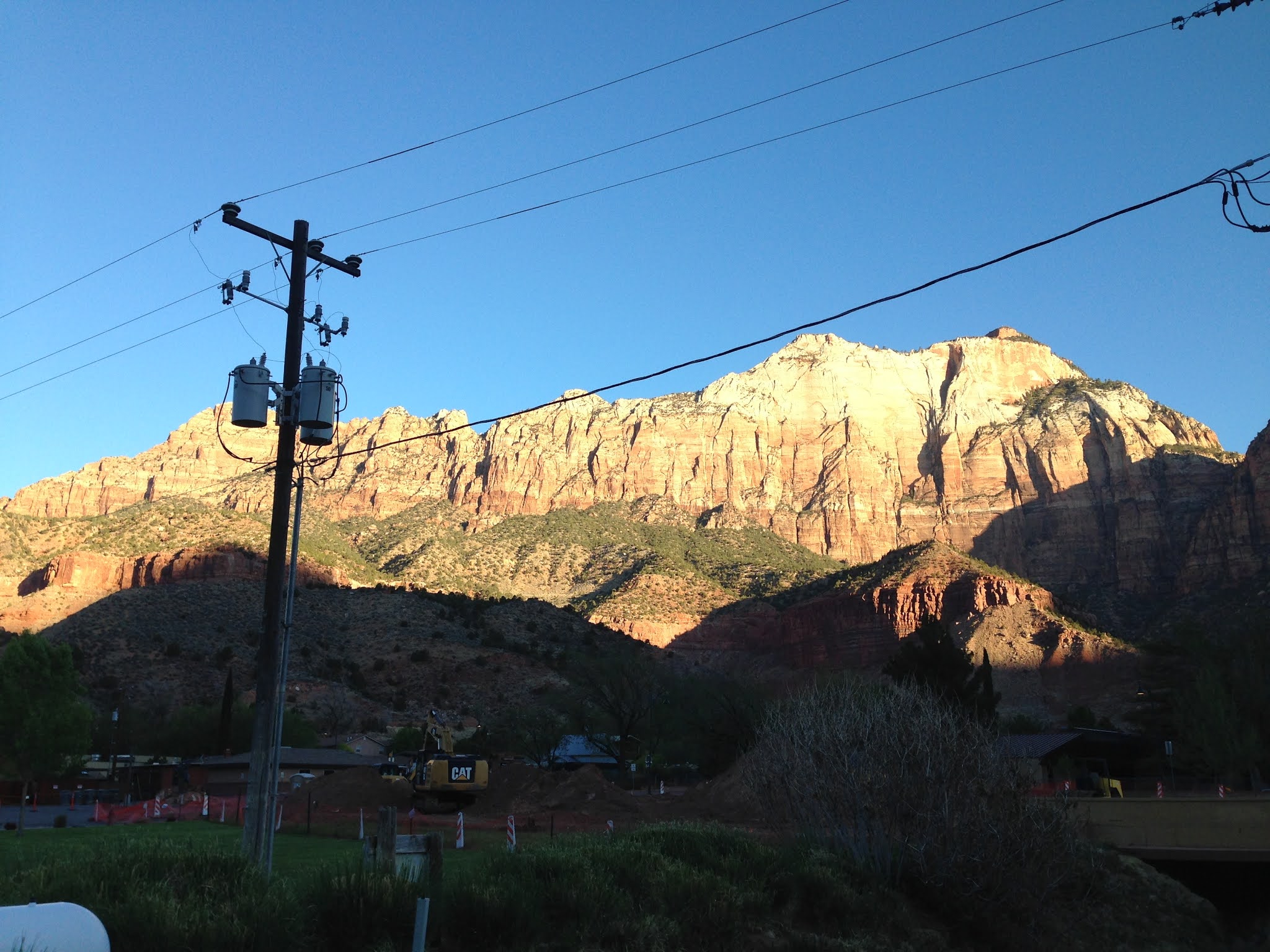
At 7:30 AM, the hills are ABLAZE:
I mailed my postcards:

and headed down the road at 8:30 AM:


I was driving through the "Kolob Canyons" section an hour later:

At the end of "Kolob Canyon Scenic Drive" (5 miles one-way) is Timber Creek Overlook Trail (an "easy" 1.1 miles out-and-back trail):

Pretty nice/flat trail, running south on the spine of a butte, with great views to the east and west:


Near the end of the trail, look west to see the "Pine Valley Mountains" (what's that WHITE STUFF???):

and look southeast to see the southern end of Zion:

But the real joy is looking east/northeast, at the Kolob Canyons:


Back at the parking area/trailhead, there is a nice plaque:


I then drove back 2 miles, parked, and hiked the "South Fork Taylor Creek Trail". It is supposed to be 2.6 miles out-and-back, but I wound up hiking 4 miles out-and-back (I know MapMyWalk got a little funky up in the Canyon):


What an adventure!!


The canyon gets narrower - looking forward:

and looking back:

Soon you are going alongside the canyon wall:


Imagine my surprise when I turned the corner and saw 4 PEOPLE ROCK CLIMBING ON THE SANDSTONE CANYON WALLS:

well, 2 were rock climbing and 2 were anchoring. Pretty Cool.
I kept going up the canyon:

um, yes, that "white stuff on the ground" is snow. The canyon floor does not get very much direct sunlight.
I stopped at 11:36 AM, when the "trail" in front of me just didn't look very inviting:

Beautiful views on the way back down:


Back to my car (and iPhone charger) by 12:15 - lunch while I'm charging. Nice view from my lunch room:

I drove a little bit, and at 12:33 I was at my final Trailhead:


This Canyon/Trail is the specific one that Thomas Moran visited in 1873, and his woodcut of the scene was published in the January 1874 issue of "The Aldine":

"Colburn's Butte, in Kannarro Cañon" is the title of the picture. Moran "named" the butte after his traveling companion, New York Times writer J.E. Colburn. The geographic feature is actually named "Tucupit Point", and the canyon is located "five or eight miles south" of the Mormon village of Kannarro (today, Kanarraville).
The trail crosses Taylor Creek several times, and the buttes appear-and-disappear as you journey up the Canyon:


3 miles in I came to the "official" end of the trail, at "Double Arch Alcove":


I don't know - even though the trail "officially ended", there was still some-sort-of-path that continued upward-and-onward. I had nowhere else to be, so I kept going. 15 minutes later I was going up THIS BEAUTIFUL VALLEY:

And 15 minutes after that (2:13 PM) I hit a BIG DEAD-END, with a ton of blow-down blocking my path:

At the top of the canyon I stopped MapMyWalk - 4.65 miles in 1 hour 40 minutes:

but now that I look at it in Google Earth, what's that ROAD down in the lower-right?? Maybe a return-trip?
I headed back down the Canyon:

At 3:33 I was back down at "Larson Cabin", which marks the turn-off for "North Fork Taylor Creek Trail":

Well, it turns out that this is not an "Official Trail". It is actually NOT EVEN CLOSE!!! After a quarter-mile, the kind-of maybe-trail just petered out, so I just turned around and headed back to the Trailhead.
Hey - pretty EXCELLENT Day anyway! 1.38 + 4 + 4.65 + 4.65 + 0.44 = 15.12 miles hiked today! Thank you God for these great adventures!!
So now to drive back to Las Vegas - 94 degrees at one point on the highway:

But it's a "dry heat".
Waiting for my 10:29 PM red-eye back to the East Coast. I can't get out of here soon enough:

My flight back east was pretty empty, so I could stretch out:


At the Raleigh-Durham Airport, I was bored so I hiked 2 times from one end of the Terminal to the other (1.6 miles total):


Thank You Ellie for picking me up at Logan Airport Friday morning!!
Thursday Hiking Music:
David Gray - Greatest Hits, 2007
 |
David Gilmour - On an Island, 2006
 |
Diana Krall - From This Moment On, 2006
 |
Dido - No Angel, 1999 debut album
 |
Dido - Dido Live, 2005 live album
 |
Then Driving Music back to Las Vegas:
Bob Marley & The Wailers - Natty Dread, 1974
 |
Dinah Washington - The Essential Dinah Washington, 2006
 |
Beyonce - "Single Ladies (Put a Ring on It)" from I Am ... Sasha Fierce, 2008
 |
Warren Zevon - My Ride's Here, 2002
 |
I listened to classical music on the airplane:
Aaron Copland - Appalachian Spring - Rodeo - Fanfare for the Common Man, 2007
 |
E. Power Biggs - Bach: The Great Preludes & Fugues, Vol. 2, 2006
 |
Rubens, Gura - Bach: St. Matthew Passion (3 cds), 2009
 |
In Raleigh-Durham, time to crank it up:
Whitney Houston - Heartbreak Hotel, 1998
 |
various artists - WM_Playground (2 songs), 2007
 |
various artists - America's Top Ten 90's Rock Hits, 2007
 |